🚨 Quick Overview
The National Hurricane Center has just dropped its first advisory on Potential Tropical Cyclone Four, previously known as Invest 97L. This storm is gearing up to hit Florida’s West Coast, potentially as Tropical Storm Debby, this weekend. Here’s the lowdown in less than a minute.
🌀 Storm Details
Current Location: Eastern Cuba, about 420 miles southeast of Key West
Maximum Winds: 30 mph
Movement: West-northwest at 16 mph
Next Advisory: 2 p.m.
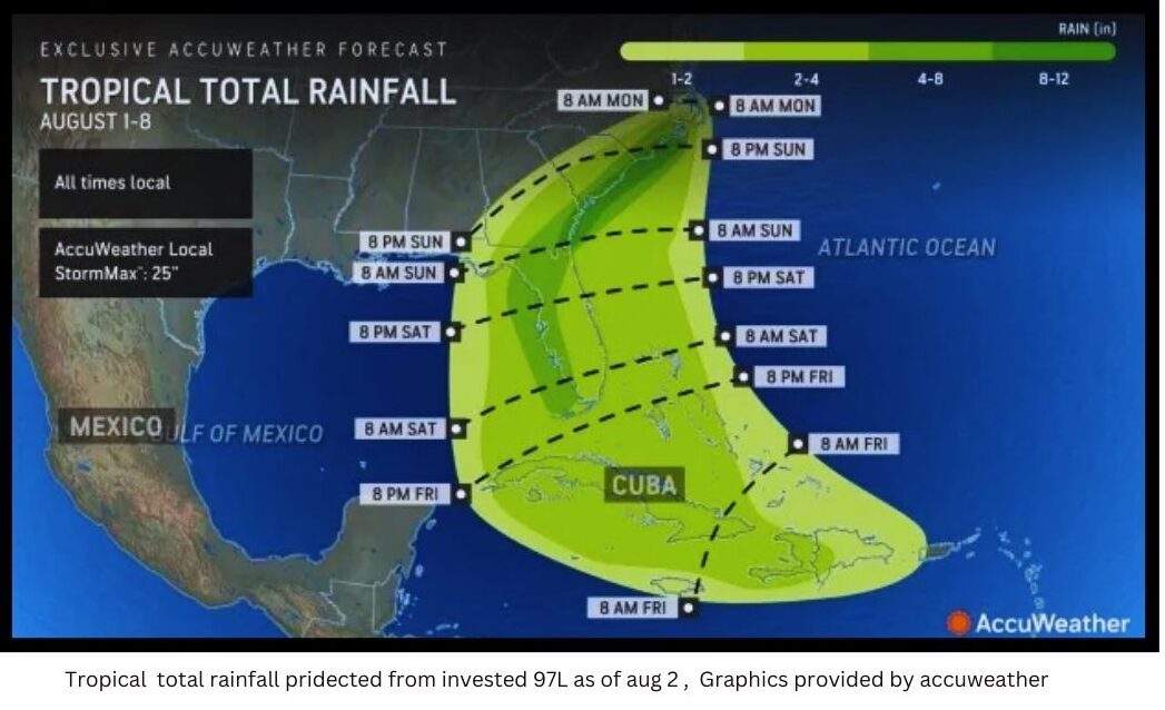
8 a.m. Friday, August 2, 2024
— Florida Weather Center (@FLWeatherCenter) August 2, 2024
Now, up to a 90%🍎chance of development.Environmental conditions are expected to be conducive for development, and a tropical depression is likely to form this weekend over the Straits of Florida or eastern Gulf of Mexico near the Florida Peninsula. pic.twitter.com/FG4oMrnw9t
🚨 Alerts & Warnings
- Tropical Storm Warning: East Cape Sable to Bonita Beach (expected within 36 hours)
- Tropical Storm Watch: Florida Keys south of Card Sound Bridge, including Dry Tortugas; East of East Cape Sable to Card Sound Bridge; North of Bonita Beach to Aripeka (possible within 48 hours)
📅 What to Expect
Path & Timing: The system is moving over Cuba today, crossing the Straits of Florida on Saturday, and potentially making landfall on Florida’s West Coast from Saturday night through Sunday night.
Strengthening: Expected to become a tropical depression on Saturday and a tropical storm by Saturday night.
Potential Impacts:
- Winds: Tropical storm conditions expected late Saturday into Sunday.
- Storm Surge: 1-3 feet above ground in Aripeka to Card Sound Bridge, Tampa Bay, and Charlotte Harbor.
- Rainfall: 4-8 inches, up to 12 inches in some areas, leading to flash and urban flooding.
🌧️ Weather Impact Highlights
- Heavy Downpours & Gusty Storms: Anticipated across Cuba and the western Bahamas, spreading over the Florida Keys and southern Florida Peninsula on Saturday.
- Urban Flooding & Waterspouts: Risks increase as the storm strengthens.
- Beach & Boating Hazards: Expect heightened rip currents along the Florida coastline.
Florida is monitoring Invest 97L in the Atlantic, which is expected to strengthen and potentially make landfall as early as this weekend. It will be slow-moving and bring lots of rain that could cause significant flooding.
— Ron DeSantis (@GovRonDeSantis) August 1, 2024
I encourage all residents to prepare for the storm and…
🚨 State of Emergency
Florida Governor Ron DeSantis has declared a state of emergency for 54 of the state’s 67 counties. He advises residents to prepare for significant rainfall and potential flooding.
🌊 Spaghetti Models & Forecast Tools
Spaghetti models are showing various paths, but the top-performing models used by the National Hurricane Center are tracking a potential landfall on Florida’s West Coast.
🌦️ Forecast Tips
- Monitor Updates: Stay tuned to local news and official weather advisories.
- Prepare: Ensure you have emergency supplies and a plan in place.
📅 Peak Hurricane Season Reminder
The Atlantic hurricane season runs from June 1 through November 30, with the peak typically around September 10. Be vigilant and prepared throughout the season.
Stay safe, Florida! Follow our updates for the latest on Potential Tropical Cyclone Four and other storm developments. 🌪️